Balls Bluff Battlefield Park Trail Map and Civil War History Guide

Leesburg · Community Photo
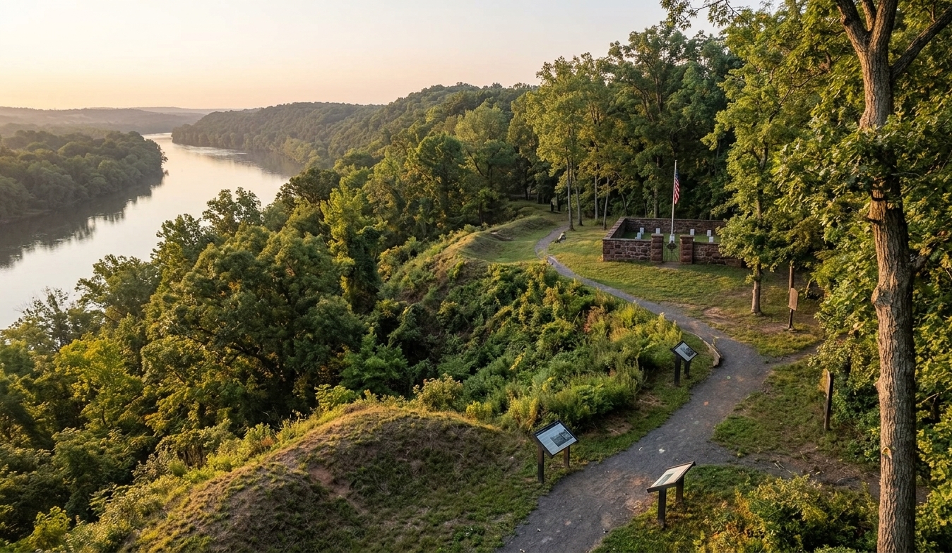
Nestled just a few miles northeast of Leesburg, this park invites you to wander along tranquil woods while tracing the historic bluffs where a pivotal October 21, 1861 battle unfolded. Visitors can follow a network of color‑blazed trails—White Interpretive, Orange, Red, Yellow, Green, Blue, and a segment of the Potomac Heritage Trail—each marked with distances from .5 to 2.1 miles, offering everything from leisurely strolls to moderate hikes. Along the way, interpretive signs reveal the story of Senator Edward D. Baker’s fatal charge and the wounding of Lieutenant Oliver Wendell Holmes Jr., moments that reshaped congressional oversight of the war. The adjoining national cemetery, one of the nation’s smallest, holds 54 Union interments across 25 graves, a solemn reminder of the sacrifice made on these slopes. Whether you’re seeking panoramic Potomac River views, a quiet spot for reflection, or a detailed trail map, this guide equips Lees‑area locals and visitors alike with the knowledge to explore both natural beauty and Civil War legacy. For those searching online, “balls bluff park leesburg” will direct you toward this comprehensive resource.
Discover the Park
Per wooded bluffs that overlook the Potomac River, Balls Bluff Park Leesburg offers a peaceful retreat amid towering trees and sweeping water views. Today visitors stroll the well‑maintained trails, yet the landscape once echoed the thunder of the Battlefield in Leesburg on October 21, 1861. That pivotal clash, the largest Civil War engagement in Loudoun County, still lingers in the quiet surroundings, inviting reflection from hikers and history lovers alike.
Why Locals Love It
Longtime residents, families, and outdoor enthusiasts gather here for picnics, birdwatching, and the simple joy of a shaded walk. The park’s managed stewardship by NOVA Parks ensures that both natural habitats and historic sites are preserved, creating a shared space where community and heritage coexist. Whether you’re seeking a sunrise over the river or a moment of remembrance at the modest national cemetery, the atmosphere remains welcoming and serene.
Trail Highlights
A network of colored blazes guides visitors through varied terrain: the White Interpretive Trail (0.8 mi) offers gentle loops, while the Orange Trail (1.7 mi) provides a longer trek that skirts historic viewpoints. Shorter routes like the Red, Yellow, Green, and Blue trails each under a mile invite quick explorations, and a 2.1‑mile segment of the Potomac Heritage Trail delivers expansive river vistas. Trail markers subtly reference the past, letting hikers piece together the story without leaving the natural setting.
History at Your Feet
Beyond the scenery, the park houses the Ball’s Bluff National Cemetery, one of the nation’s smallest, honoring 25 Union soldiers. The site’s somber spirit is complemented by interpretive signs that recount the loss of Senator Edward D. Baker and the wounding of future Supreme Court Justice Oliver Wendell Holmes Jr. For those eager to explore further, the comprehensive Balls Bluff Battlefield Park Trail Map and Civil War History Guide provides detailed routes and contextual narratives, turning every footstep into a walk through America’s past.
The Battle of Ball's Bluff: What Happened on October 21, 1861
Strategic Context
The Battle of Ball's Bluff on October 21, 1861 unfolded on the steep Potomac bluffs just south of Leesburg. After the Union loss at First Bull Run, General George B. McClellan ordered a reconnaissance to assess Confederate activity near the river, setting the stage for the clash.
Stone’s Scouting Orders
Brigadier General Charles Pomeroy Stone directed Captain Chase Philbrick of the 15th Massachusetts to lead a twenty‑man patrol across the Potomac on the night of October 20. In moonlit mist the men mistook a line of trees for an unguarded Confederate camp, prompting Stone to commit roughly 350 troops under Colonel Charles Devens for a dawn raid.
Crossing from Harrison’s Island
Harrison’s Island served as the staging point for the Union crossing. A handful of small boats and a single scow shuttled soldiers to the Virginia shore, creating a bottleneck that left the force vulnerable once enemy fire opened.
Escalating Clash and Baker’s Death
When the false‑camp report proved empty, Confederate forces under Colonel Nathan Evans struck the Union contingent. Senator and Colonel Edward Dickinson Baker arrived to command the field, but he failed to secure additional transport. Amid a fierce Confederate push, Baker was shot multiple times and became the only sitting U.S. senator ever killed in combat.
Holmes’s Wounds and Aftermath
Among the Union casualties was 20‑year‑old Lieutenant Oliver Wendell Holmes Jr., later a Supreme Court Justice. He sustained two chest wounds—one that passed through a lung and narrowly missed his heart—before being evacuated back to Harrison’s Island.
Casualties and Political Fallout
Union losses ranged from roughly 921 to 1,002, while Confederate casualties were about 155, illustrating the severe battle of Ball's Bluff casualties. The defeat and Baker’s death inflamed Congress, leading to the creation of the Joint Committee on the Conduct of the War. Visitors seeking a comprehensive Ball's Bluff Battlefield Park Trail Map and Civil War History Guide can explore the site’s interpretive trails and historic markers.

Ball's Bluff
October 21, 1861 · Leesburg, VA
Key Figures


Political Aftermath

Trail Network
Ball's Bluff National Cemetery

Plan Your Visit
Leesburg, VA 20176
Free admission
April – November · Free
Ball's Bluff Trail Map and Hiking Trail Guide
Trail Name | Blaze Color | Distance | Difficulty / Terrain | Highlights & Points of Interest |
|---|---|---|---|---|
White Interpretive Trail | White | 0.8 mi | Easy / Moderate | Battlefield loop with interpretive markers and cannon placements; appears on the park’s official trail map. |
Orange Trail | Orange | 1.7 mi | Moderate | Perimeter woodland walk showcasing spring wildflowers; highlighted on the trail map. |
Red Trail | Red | 0.75 mi | Moderate | Wooded interior trail connecting ridges; part of the park’s hiking trail network. |
Yellow Trail | Yellow | 0.6 mi | Moderate | Creek valley and southern woods offering quiet scenery. |
Green Trail | Green | 0.6 mi | Easy / Moderate | Connects trailheads and circles the National Cemetery perimeter. |
Blue Trail | Blue | 0.5 mi | Moderate | Scenic side spurs with occasional overlook points. |
Potomac Heritage Trail | Varied / standard markers | 2.1 mi | Moderate / Rugged | Direct riverfront path along the Potomac base; this segment is the Potomac Heritage Trail and serves as a notable hiking trail on the trail map. |
Classic History Walking Tour
The White Trail loop, at roughly 0.8 miles, serves as the park’s signature walking tour. It winds through an open meadow and past a series of interpretive signs that explain the October 21, 1861 battle, the death of Senator Edward Baker, and the wounding of Lieutenant Oliver Wendell Holmes Jr. Highlights include the tiny Ball’s Bluff National Cemetery, where just 54 Union interments rest, and the Ball’s Bluff Overlook that crowns a 100‑foot bluff above the Potomac River.
Potomac River & Bluff Perimeter Loop
For those seeking a longer hike, the Orange Trail (1.7 mi) joins a segment of the Potomac Heritage Trail to create a circuit of about 2.1 miles. This route follows the riverbank before climbing back up the ridge, delivering sweeping Potomac River view points toward Harrison’s Island and the surrounding Virginia channel. The loop showcases the park’s natural scenery while still threading historic markers that note Union positions and troop movements.
Practical Trail Advice
All routes are free and open from dawn to dusk, so a sturdy pair of hiking boots is strongly recommended—especially for the steep, rocky sections that descend the bluff toward the riverbank. Dogs are welcome but must remain leashed at all times. Spring hikers should watch for seasonal mud and wet spots along the lower river path, and carrying insect repellent can make the experience more comfortable during warmer months.
Whether you are a history enthusiast or a casual hiker, this guide offers the essential details to enjoy the park’s trails and the rich legacy captured in the balls bluff battlefield park trail map and civil war history guide.
National Cemetery and Historical Markers on the Battlefield

National Cemetery and Battlefield Monuments
Within the 223‑acre park lies Ball’s Bluff national cemetery, recognized as one of the smallest such sites in the United States. The half‑acre, stone‑walled plot contains 25 numbered headstones that mark the remains of 54 Union soldiers who fell on October 21, 1861. Only a single interment is identified by name—Private Clinton James of Company H, 15th Massachusetts Volunteer Infantry.
Just beyond the cemetery’s perimeter stands a solitary Confederate memorial honoring Sergeant Clinton Hatcher of Company F, 8th Virginia Infantry. Although the granite marker commemorates his service, Hatcher’s actual burial is at the nearby Ketoctin Baptist Church Cemetery.
Across the adjacent meadow, historic field cannons are positioned to illustrate the artillery locations used during the battle. Complementing these pieces are several historical markers erected by NOVA Parks that detail shifting battle lines, tactical decisions, and the dramatic retreat down the 80‑foot bluff, giving visitors a vivid sense of the conflict.
Each year, the park partners with local organizations to host public outreach programs, guided walks, and a balls bluff reenactment that brings the Civil War drama to life. These commemorative events and living‑history demonstrations help preserve the legacy of the battlefield for residents and visitors alike.
Planning Your Visit: Park Hours and Visitor Logistics
Visitor Quick Facts
Ball’s Bluff Battlefield Regional Park sits at 42314 Balls Bluff Road NE, Leesburg, VA 20176, and is managed by the Northern Virginia Regional Park Authority (NOVA Parks). The park is open daily from dawn to dusk year‑round, providing ample flexibility for early risers and late afternoon explorers.
Admission is free, and a paved parking lot located at the trailhead welcomes cars, bikes, and accessible vehicles. This convenient on‑site lot serves as the hub for the kiosk that launches both self‑guided walks and scheduled guided tours, streamlining visitor logistics the moment you arrive.
For those planning a hike, the trail system includes colored blazes ranging from short 0.5‑mile loops to a 2.1‑mile segment of the Potomac Heritage Trail, all of which begin at the central parking area. Trailheads are clearly marked, and the park’s signage highlights historic points such as the Civil War battlefield and the nearby national cemetery.
Remember to practice Leave No Trace principles: please take all trash with you when you leave. By keeping the grounds pristine, every guest helps preserve the historic landscape of Balls Bluff Park Leesburg for future generations.
Weekend Guided Walking Tours
Explore the historic grounds with a free volunteer‑led walking tour scheduled at 11 a.m. and 1 p.m. on Saturdays and Sundays from April through November. Guides gather near the main kiosk and lead visitors along the key points of the battlefield.
Pet Regulations
Dogs are welcome on all hiking trails provided they are on a physical leash. Owners must pack out all waste to keep the park tidy.
Trail Accessibility
Crushed‑stone paths connect the parking area to Ball’s Bluff National Cemetery and offer a relatively level surface for easy access. In contrast, the routes that descend the steep bluffs toward the Potomac River are natural‑dirt, rugged, and best suited for experienced hikers.
Seasonal Highlights
Mid‑April brings a carpet of bluebells and other wildflowers along the river bluffs, while October showcases vibrant autumn foliage during the battle’s anniversary celebrations.
Trailhead Amenities
Parking lot
Interpretive kiosk
Trail maps
Portable restrooms
Park Hours & Visitor Logistics
The park is open daily from dawn to dusk, with free admission for all guests. Parking is available adjacent to the kiosk, where visitors can also obtain a balls bluff battlefield park trail map and civil war history guide. Restroom facilities are portable, and signage helps orient hikers to trailheads and historic sites.